
Caroline Scharf
Vice President of Operations

Our team just got back from the GEOINT 2017 Symposium where we partnered with the Oracle National Security Group to visualize all the world’s news in near-real time. The demonstration shows how one could conduct cyber threat analysis and geospatial intelligence on a massive, diverse data set, in this case, the GDELT Global Knowledge Graph.
I sat down with Kevin Madden, our Chief Software Engineer, and Deborah Baron, our Marketing Vice President, to uncover why Tom Sawyer Software is the best-kept secret in geospatial intelligence. We also discussed what was special about partnering with Oracle at the annual Symposium.
What does Tom Sawyer Software provide for the geospatial intelligence community?
Deborah: We are a member of the United States Geospatial Intelligence Foundation (USGIF) and support the Geospatial Intelligence (GEOINT) community and events. Our technology provides organizations with sophisticated graph and data visualization and analysis software for geospatial intelligence applications.
For example, a large federal intelligence customer uses our technology to filter, visualize, and analyze nearly two billion entities—people, places, events, and activities—from INTERPOL and domestic sources across over 300 million cases.
Kevin: We’ve been working with US Federal customers and defense systems integrators for many years. Typically, we work on mission-critical projects that protect the safety and security of our country.
Recently the GEOINT community expressed an urgent need to integrate massive datasets from disparate sources and combine physical and logical views of data in a single interface. It turns out that Tom Sawyer Perspectives, our flagship product, excels at this. Ours is the only platform to integrate and fully synchronize geospatial and topological data, as well as tabular information, charts, and timelines.
Why has Tom Sawyer Software been a well-kept secret in the cyber threat analysis and geospatial intelligence community?
Kevin: We have been a secret because we work behind the scenes with most of our federal customers and integrators who can’t talk about their mission-based projects. We can’t tell you about what they’re doing, but we can tell you why they turn to us.
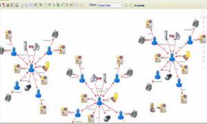
Many federal customers require a single, unified view of link analysis, timelines, charts, and tabular data combined with topological and geospatial data, across massive, diverse sources. We provide this capability in a user-friendly, fully synchronized interface.
For example, law enforcement and investigators nationwide use our visualizations to analyze and map locations, crimes, suspects, victims, and their relationships and connect across cases to uncover hidden patterns and identify threats.
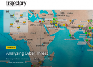
Deborah: We were the best-kept secret in geospatial intelligence until the last day of the GEOINT Symposium. That’s when we were featured in the USGIF’s daily publication, Trajectory Magazine. During the GEOINT Symposium, Oracle showcased our jointly developed GDELT Global Knowledge Graph demonstration in their booth and invited our team to present in their theater. More on that later.
Tom Sawyer Software’s partnership with Oracle certainly opened some eyes at the Symposium. Tell us more.
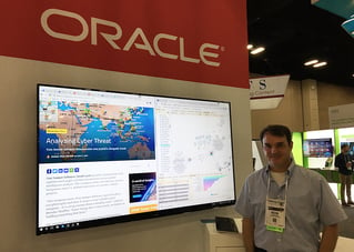
Kevin: We are the premier graph and data visualization partner for Oracle. We partnered on many geospatial solutions to show attendees at the GEOINT Symposium. Our featured solution for cyber threat analysis was developed by our solutions engineering team and Oracle’s Spatial team. We showed the feature solution in their exhibition area as well as ours.
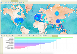
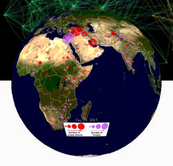
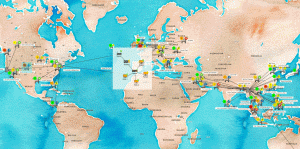
In this solution, Oracle pulled over thirty-six terabytes of data and ten thousand categories from the GDELT Project’s Global Knowledge Graph into the Bare Metal Cloud and Oracle 12c. Then, we integrated Tom Sawyer Perspectives with Oracle to power our geospatial intelligence visualization and analysis demonstration.
Because of Tom Sawyer Perspectives’ unique power and ability to integrate with Oracle and process the vast amount of data from the GDELT Project, attendees were able to see the important connections between themes, people, places, and events, that would normally be hidden or hard to distill.
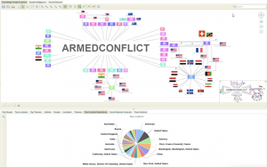
At a high-level, we help the GEOINT community visualize relationships between people and events to analyze cyber threats and criminal activity on a global scale. Customers integrate our software into their desktop and web-enabled applications, and federate and drill into real-time data from multiple sources, including Oracle 12.2c, Cloud and Big Data Spatial and Graph databases, Neo4j, SAP/HANA, and many others to visualize and analyze emerging threats.
What else did Tom Sawyer share with Symposium attendees?
Deborah: For the first time ever, we shared our graph visualization demonstrations—such as the Panama Papers analysis, crime network investigations, link analysis, and network topology—running on Oracle Bare Metal Cloud, Oracle 12c and Oracle Spatial and Graph databases. Attendees saw just how well Tom Sawyer Perspectives integrates with disparate sources.
Attendees saw the best graph visualization, layout, and analysis software for unmatched drawing quality, performance, agility, and scalability. They found our unified views of logical and topological views that enable organizations to analyze cyber threats compelling to see in action.
Kevin: We also showcased our brand-new Tom Sawyer Maps functionality. It combines the power of our existing rule-based drawing views and the OpenLayers map library. By combining drawings and maps, we provide an exciting new way to view geospatial data and introduce features that are not available in either of these technologies separately.
Overall what were some of your favorite highlights from GEOINT?
Kevin:
-
Tom Sawyer Software Featured in USGIF’s Trajectory Magazine for the GEOINT Symposium We further developed our relationship with Oracle as a partner. Our solutions engineering teams worked closely with theirs over several weeks to build an application to demo during GEOINT. Our marketing teams coordinated communications to drive awareness of this incredible solution.
- The joint geospatial intelligence solution we created with Oracle proved we could integrate a vast amount of data from various sources. The ability to take 36 terabytes of data, place it on Bare Metal Cloud, and integrate it with Oracle has never been done before. It was a great achievement for our team and a chance to show off the power behind Tom Sawyer Perspectives.
- GEOINT was a great opportunity to meet with the experts and decision makers in geospatial intelligence. We could share information, learn about their challenges and objectives, and demonstrate our software live. The conversations we had helped us deepen our relationships with our customers, stay current with industry trends, and learn about industry requirements.
Caroline: The Symposium sounds like it was a great event. Thanks for sharing your experiences.
Deborah: Thanks, Caroline! To get started with Perspectives now, click here.
About the Author
Caroline Scharf, VP of Operations at Tom Sawyer Software, has more than 25 years leadership experience at large and small software companies. She has a passion for process and policy in streamlining operations, a solution-oriented approach to problem solving, and is a strong advocate of continuous evaluation and improvement.
Submit a Comment